- 06 Days
- Tour Start: Moshi
- Tour End: Moshi
- Min Age: 02
Tour Details
Overview
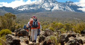
Originally the foundation of Lemosho route, simply Lemosho is the improved diversion. Shira route also starts from the Southern-western side of the mountain. On the Second day the route merge with Lemosho and together they follow the southern circuit route to the summit.
Itinerary
Day 1: Shira Gate to Shira Camp
Elevation (m): 1830m to 3840m
Elevation (ft): 6000ft to 12,600ft
Distance: 18km
Hiking Time: 5-7 hours
Habitat: Montane Forest
The drive from Moshi to the trailhead takes about 3 hours. We walk through the rain forest on a winding trail up a ridge. Lower down, the trail can be muddy and slippery. Gaiters and trekking poles are a good idea here. We continue a short distance until we reach the Shira Camp.
Day 2 :Shira Camp to Lava Tower to Barranco Camp
Elevation (m): 3840m to 4630m to 3860m
Elevation (ft): 12,600ft to 12,700ft
Distance: 15 km Walking
Time: 5-7 hours
Habitat: Semi-desert
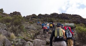
From the Shira Plateau, we continue to the east up a ridge, passing the junction towards the peak of Kibo . Your direction would change to the South Eastward towards the Lava tower, that is popularly known as the “Shark’s Tooth.” The second junction shortly after the tower is the Arrow Glacier which is at an altitude of 4,876 meters. Now we would start descending to an altitude of 3,860 meters to rest and enjoy our dinner at the Barranco Hut. Our overnight stay would be at this hut. No doubt this would end your day’s trip but the acclimatization would keep your body fit and help you to be prepared for the summit day.
Day 3: Barranco Camp to Karanga Camp
Elevation (m): 3860m to 4200m
Elevation (ft): 12,700ft to 13,800ft
Distance: 7 km
Hiking Time: 4 hours
Habitat: Alpine Desert
After breakfast, we leave Barranco and continue on a steep ridge passing the Barranco Wall, to the Karanga Valley campsite
Day 4: Alpine Desert
Elevation (m): 3860m to 4600m
Elevation (ft): 12,700ft to 15,100ft
Distance: 13km Hiking
Time: 8 hours
Habitat: Alpine Desert
After breakfast, we leave Barranco and continue on a steep ridge up the Barranco Wall, through the Karanga Valley (lunch at 4200m), and the junction, which connects, with the Mweka Trail.
We continue up to the Barafu Hut. You have completed the South Circuit, which offers views of the summit from many different angles. Here we make camp, rest, enjoy dinner, and prepare for the summit day. The two peaks of Mawenzi and Kibo are to be seen from this position.
Day 5: Barafu Camp to Summit to Mweka Hut
Elevation (m): 4600m to 5895m (and down to 3100m)
Elevation (ft): 15,100ft to 19,300ft (and down to 10,200ft)
Distance: 7km ascent / 23km descent
Hiking Time:6- 8 hours ascent / 7-8 hours descent
Habitat: Stone scree and ice-capped summit Very early in the morning (midnight to 2am), we continue our way to the summit between the Rebmann and Ratzel glaciers. You head in a northwesterly direction and ascend through heavy scree towards Stella Point on the crater rim.This is the most mentally and physically challenging portion of the trek. At Stella Point (5685m), you will stop for a short rest and will be rewarded with the most magnificent sunrise you are ever likely to see (weather permitting).From Stella Point, you may encounter snow all they way on your 1-hour ascent to the summit. At Uhuru Peak , you have reached the highest point on Mount Kilimanjaro and the continent of Africa .
Faster hikers will see the sunrise from the summit. It can be very cold at night at these elevations, but it will be quite warm by the end of the hiking day. You will want clothing for both extremes with you. From the summit, we now make our descent continuing straight down to the Mweka Hut camp site, stopping at Barafu for lunch. You will want gaiters and trekking poles for the loose gravel going down. Mweka Camp is situated in the upper forest and mist or rain can be expected in the late afternoon. Later in the evening, we enjoy our last dinner on the mountain and a well-earned sleep.
Day 6: Mweka Camp to Arusha
Elevation (m): 3100m to 1830m
Elevation (ft): 10,200ft to 6000ft
Distance: 15 km
Hiking Time: 3-4 hours
Habitat: Forest
After breakfast, we continue the descent down to the Mweka Park Gate to receive your summit certificates. At lower elevations, it can be wet and muddy. Gaiters and trekking poles will help. Shorts and t-shirts will probably be plenty to wear (keep rain gear and warmer clothing handy). From the gate, continue another hour to Mweka Village. A vehicle will meet you at Mweka village to drive you back to hotel in Arusha.
Don’t forget to tip your guides and porters it is time for celebration! Departure Pick up from your hotel in town then transfer to Kilimanjaro International Airport to catch your flight back home.
Inclusion
Price Includes
- All park fees including rescue fee
- All meals and accommodation during the trek
- Crew allowances
- Transfer to and from the gate
- Camping equipment i.e. tents, tables and Chairs
Price Excludes
- International flight tickets and visa
- Tips
- Personal items (Souvenirs, travel insurance, visa fees, etc.)
- Accommodations before during and after the climb
- Travel Insurance